First things first: download the app here. Now that you have downloaded the app you can open it to see the homepage. You will notice the usual suspects: the ISS and Iridium Flares schedules. If you are searching for a specific satellite, scroll down to “Search satellites” and enter the one you want to find; OTV-4, Tiangong 1, N Korean Satellite, Hubble Space Telescope, and Envisat are the ones featured on Heavens-Above and will have a great set of 10 Day predictions.
One of my personal favorite things Heavens Above provides is a list of all the visible satellites for every morning/night. This list is under “Nightly Events.” I’d recommend if it is you first time looking for a satellite besides the ISS and Iridium Flares you try for satellites with a 2.0 brightness and lower. This goes for the 10-Day predictions too. It is sometimes best to wait a couple days for a brighter pass; most of those can shine even below a 1 in apparent magnitude. Again, like the ISS and Iridium Flares, if you don’t find a time that works with a good apparent magnitude just wait another 10 days for a new set of dates and times.


So you have picked out the satellites and times you are going to try to spot, how do you spot it?
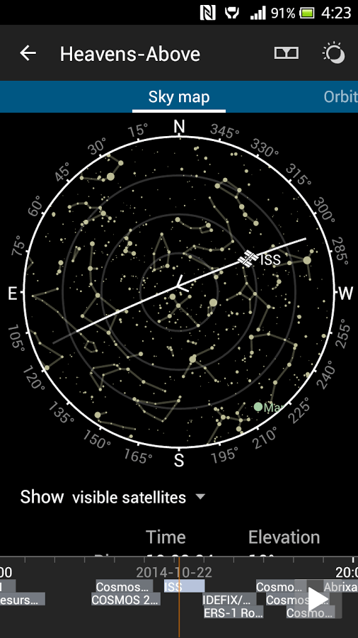
If you click on the event you want to see it will bring up a map for you to find it in the sky as shown above. This map doesn’t move based on your phone’s direction; you will have to point your phone North to use it correctly. If you don’t know exactly where north is from where you are, you will need to bring a compass with you to your site… or use the compass on your phone if you don’t have one or are too lazy to go digging through the house for it. The map is a great visual representation of the dome above your head but keep in mind that the map is a circle and not a dome so they use the little gray circles to indicate how high above you the location is. For example, if the line goes through the tiniest circle in the middle that means the object will travel directly over your head (or at the highest point). How high an object is in the sky matters a lot when looking for satellites. The lower in the sky you are looking, the more atmosphere is going to distort your image. This can be useful when you are picking out which satellites to spot. Like the apparent magnitude, elevation can tell you how easy it is to find an object. The elevation is how high in the sky you need to be looking: 0 is the horizon and 90 is if you were to look straight up. So something at 10 is starting pretty low in the sky and wouldn’t be easy to spot because it is in very thick atmosphere. Thus when I go looking for satellites, I usually only attempt when the elevation is above 45. I would recommend if this is your first time looking for a satellite to try for a time when the elevation is around 80 and above. It will be easier to track the satellite higher in the sky.